Methods for Post-Processing Kelp-O-Matic Output1
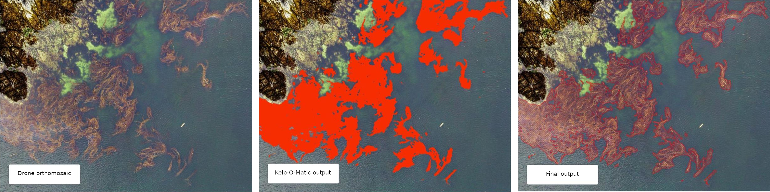
This document describes the methods used for generating analysis ready data on species-level kelp extent from outputs from the Kelp-O-Matic tool. Final outputs consist of polygon features (.shp) that contain species-level classification of emergent canopy kelp present in drone imagery.
These instructions assume a basic level of experience with the ArcMAP GIS interface. For questions, please contact Luba Reshitnyk at the Hakai Institute.
Workflow Overview
graph TB
    A[/"Raw KoM output (.tif)"/]-- Open in ArcGIS -->B["Convert to polygon feature (raster to polygon)"];
    B-->edit
    subgraph edit [Edit]
        direction TB
        C[Remove polygons < 0.2m<sup>2</sup>]-->D[Manually remove non-kelp polygons];
        D-->E[Manually digitize kelp canopy that was missed];
        E-->F[Fix any misclassified species];
    end
    edit-- Have secondary analyst review, time permitting -->G[/"Final output (.shp)"/]
Detailed Workflow
This section assumes that you have obtained output from the Kelp-O-Matic (.tif) and have a new instance of ArcMap (version 10.8). These same steps can be done using other GIS software (e.g. QGIS)
Tip: ArcMap Keyboard Shortcuts
Keyboard shortcuts can make the editing process much faster. To enable some, go to Customize > Customize Mode > Keyboard….
Some useful shortcuts include:
- Edit tool (set to Ctrl+E)
- This lets you toggle to the editor tool.
- Delete (set to Ctrl+D)
- Delete selected polygon features.
- Freehand tool (set to Ctrl+R)
- Toggle to freehand tool to manually digitize kelp feature polygons.
- Clip (set to Ctrl+W)
- Quickly draw a polygon then click ctrl+W to delete the polygon features within the newly drawn polygon. Then delete that polygon.
Load Kelp-O-Matic Raster
Load the output .tif file from Kelp-O-Matic into ArcMap. The raster will have the following
attributes:
| Output value (gridcode) | Class |
|---|---|
| 0 | Background |
| 1 | Kelp (presence mode) |
| 2 | Macrocystis (species mode) |
| 3 | Nereocystis (species mode) |
Convert to Polygons
Convert this raster into polygons using the Raster to Polygon tool in ArcMap.
- Uncheck "simplify polygons"
- Leave the other defaults as they are
Add New Attributes to Polygons
- Add a new "area" field
- Right click layer in the table of contents
- Select
Open attribute table > Table options > Add field- Name = "area"
- Type = "float"
- Click
OK
- Calculate the area for each polygon
- Right-click the "area" header in the attribute table, select
Calculate Geometry...- Property = "area"
- Units = "square meters"
- Coordinate system = choose an appropriate projection that preserves area (e.g. NAD83 BC Albers Equal Area EPSG = 3005)
- Click "OK"
- Right-click the "area" header in the attribute table, select
- Add a new "species" field
- Right click layer in the table of contents
- Select
Open attribute table > Table options > Add field- Name = "species"
- Type = "text"
- Click
OK
Editing and Data Cleaning
Delete small polygons that are unlikely to be kelp
- Start editing this feature polygon layer
- In the Editor toolbar click
Editor > start editing. Select the feature layer you will be editing
- In the Editor toolbar click
- Right click layer in the table of contents, Select
Open attribute table. ClickSelect by attribute - Select features < 0.2 m2 by typing:
"area" < 0.2 - Right click highlighted features in attribute table and click
Delete Selected - Save edits
Manually delete non-kelp polygons
There may be areas where KoM classifier falsely detected kelp and these polygons need to be removed manually.
- Select using the edit tool or “Select by Lasso” tool
- Delete the selected polygon(s)
- Save edits.
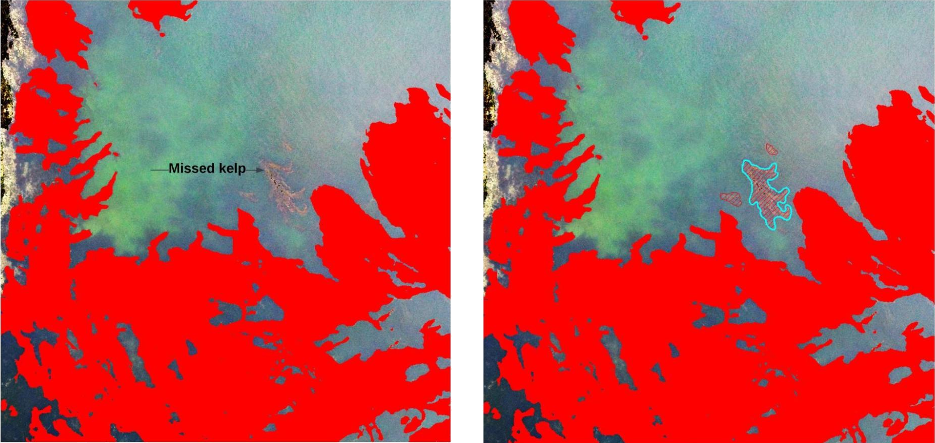
Add kelp not detected by KoM
If there are locations where emergent canopy kelp was missed by the KoM classifier (example in figure below) manually digitize these features using the Freehand Tool. You will need to manually classify these new regions to species (change value in the attribute table). A 1:100 scale is recommended.
Review Species Attributes
There may be some areas where the KoM classifier misclassified the species in a given area. These polygons can be edited manually. If you're just interested in presence/absence don't worry about this step.
- Select all polygon features classified as giant kelp by opening the attribute table and “select
by attribute”. Select features representing giant kelp by typing:
"gridcode" = 2. At the bottom of the attribute table click on the "Show selected records" tab. - Right-click the "species" field you created earlier. Select "Field Calculator".
- In the text box enter "Macrocystis pyrifera" (with quotes included) and click OK. This will fill out that attribute for all the selected polygons.
Repeat steps 1 - 3 for bull kelp by using "gridcode" = 3 and "Nereocystis luetkeana".
- Review all the polygon species classification and manually change ones that the KoM classifier misclassified by changing the text in the "species" field for that polygon feature.
- Save edits.
- Delete the "gridcode" attribute once you are done.
- Save edits.
Export Data
That's it! You can now export your data a shapefile and give it an appropriate name.
Authors: Luba Reshitnyk and Taylor Denouden
-
Created by Luba Reshitnyk, February 2023 ↩